
Topcon Introduces CR‑S1 Handheld Scanning System
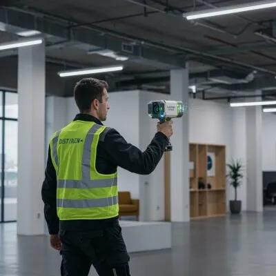
Topcon Positioning Systems has unveiled the CR‑S1, a cutting-edge handheld scanning system that integrates multiple advanced sensing technologies into a single device. This innovative system combines LiDAR, panoramic cameras, visual SLAM cameras, and a GNSS antenna, providing users with a versatile solution for capturing highly accurate spatial data. Designed to streamline complex surveying and mapping tasks, the CR‑S1 is part of Topcon’s Capture Reality portfolio and leverages the company’s Collage mass-data software ecosystem, which acts as a central hub in a connected and collaborative workflow.
Enhanced Capture Reality Portfolio
The CR‑S1 expands Topcon’s Capture Reality portfolio by offering a higher-performance option alongside the CR‑S2 model. With this addition, Topcon provides users with more flexibility in choosing a scanning solution that matches their project requirements. The CR‑S1 distinguishes itself through increased point-cloud density, an extended scanning range, and upgraded panoramic imaging capabilities. These features make it ideal for a wide range of applications, including land surveying, tunnel surveying, forestry analysis, mining operations, utility mapping, and power line inspection. Its design ensures that both indoor and outdoor environments can be captured with precision.
Optimized Workflow and User Flexibility
According to Ron Oberlander, head of the Topcon Geomatics Platform, customers are seeking solutions that provide flexibility and efficient workflows. The CR‑S1, combined with Topcon’s software ecosystem, meets these needs by simplifying processes, supporting open integrations, and enabling compatibility across mixed fleets of devices. With Collage as the central data hub, users can collect and process inputs from multiple sensors, resulting in accurate and detailed datasets that support informed decision-making in the field.
Software Integration and Support
The CR‑S1 is supported by a suite of software solutions designed to streamline data capture, processing, and visualization. These include MAGNET Flow, available for both Android and iOS devices, which allows field teams to manage scanning operations and monitor data collection in real time. MAGNET Bridge enables desktop processing of SLAM data, providing enhanced computational capabilities for large-scale projects. At the center of the workflow is Collage Web, a cloud-based platform that allows fast visualization, exploration, and sharing of 3D point-cloud data directly in a web browser.
Collage Web for Cloud-Based Collaboration
Collage Web enhances collaboration by enabling teams to easily view and inspect datasets online, without the need for specialized software installations. Through the Collage Cloud Connector desktop application, projects can be synchronized seamlessly with Collage Web, ensuring that all team members have access to the latest data regardless of their location. This integration supports interoperability with widely used industry platforms, including Autodesk and ClearEdge3D, allowing users to incorporate data from the CR‑S1 into broader design and analysis workflows. By supporting mixed fleets and diverse industry systems, Topcon ensures that data exchange remains efficient and project access consistent across both desktop and cloud environments.
Improved Positioning Accuracy
For users requiring enhanced positioning precision, the CR‑S1 can connect to the Topnet Live RTK GNSS corrections service. This connection ensures high-accuracy positioning for mapping and surveying applications, even in challenging or complex environments. By combining multiple sensors and GNSS support, the CR‑S1 delivers reliable spatial data for critical infrastructure and construction projects.
Versatile Mounting Options
The CR‑S1 offers flexible mounting configurations to suit a variety of operational needs. The system can be used in a backpack or front-pack setup, enabling hands-free, load-bearing scanning while walking through survey areas. For traditional surveying tasks, it can also be mounted on a rover pole, providing a familiar interface for field technicians. Additionally, an adapter is available for mounting the CR‑S1 on a vehicle, making it possible to perform mobile mapping operations efficiently and safely. These mounting options allow users to adapt the system to different project types, terrains, and operational constraints.
Ideal Applications Across Industries
The CR‑S1 is designed to serve a wide range of industries and applications. In construction, it enables rapid and precise site surveys, aiding in project planning and monitoring. Land surveyors benefit from its high-density point clouds and GNSS integration for accurate topographical mapping. In mining and forestry, the CR‑S1 captures complex terrain and vegetation with high resolution, supporting resource management and operational planning. Utility companies and power line operators can utilize the system for inspection and maintenance tasks, reducing the time and labor required for traditional survey methods.
Centralized Data Management with Collage
By utilizing Topcon’s Collage platform, users can centralize data management and maintain consistency across projects. Collage allows for the efficient processing, analysis, and visualization of large datasets generated by the CR‑S1, ensuring that teams can collaborate effectively and make data-driven decisions. The platform also supports real-time updates and version control, which is critical for projects that involve multiple stakeholders and require accurate, up-to-date information.
Future-Proofing Surveying and Mapping
Topcon’s introduction of the CR‑S1 represents a step forward in modernizing surveying workflows. By integrating LiDAR, panoramic imaging, visual SLAM, and GNSS in a compact, handheld system, Topcon is providing a future-proof solution that addresses the evolving needs of surveyors, engineers, and mapping professionals. The combination of versatile hardware, powerful software support, and flexible deployment options ensures that the CR‑S1 can handle the demands of today’s projects while remaining adaptable for future technologies.
The CR‑S1 handheld scanning system solidifies Topcon’s leadership in the Capture Reality portfolio, offering a high-performance, flexible solution for a variety of surveying and construction applications. With advanced sensor integration, cloud-based collaboration, and enhanced workflow efficiency, the system empowers users to collect accurate, detailed data with ease. Whether on foot, mounted on a pole, or deployed on a vehicle, the CR‑S1 provides the versatility and precision required to meet the complex demands of modern surveying and mapping operations.
Source link: https://www.businesswire.com/