

Topcon Positioning Systems has unveiled a new suite of solutions aimed at revolutionizing 3D mass data workflows, introducing enhancements that promise faster, more accurate, and more efficient data processing and visualization. At the core of this advancement is the newly upgraded Topcon Collage Site software, now equipped with real-time georeferenced point cloud capabilities that significantly improve field-based data acquisition and decision-making.
The latest developments are part of Topcon’s Capture Reality product line—an integrated platform that provides cutting-edge tools for professionals in construction, geospatial, and related sectors who require highly detailed 3D data to optimize their workflows.
Topcon’s Collage Site software now allows operators to scan, process, and view fully georeferenced point clouds while still on-site. This innovation means field personnel can immediately evaluate the completeness and quality of the scan data without needing to return to the office or revisit the job site to fill in missing or inaccurate information.
When paired with compatible hardware, including the newly released Topcon CR-P1 3D laser scanner, users can generate real-time point cloud models that provide actionable data. These models are ready for use across a variety of applications, from construction verification and infrastructure inspection to as-built documentation and digital twin creation.

“Today’s construction and survey environments are under increasing pressure due to rising infrastructure demands, ongoing labor shortages, and material cost escalations,” said Murray Lodge, Executive Vice President at Topcon Positioning Systems. “Our goal is to equip professionals with solutions that provide faster, more accurate data collection, helping them to make informed decisions and deliver better outcomes across the board.”
The enhanced workflow capabilities introduced in Collage Site were designed with a diverse user base in mind. From seasoned surveyors to newcomers in scanning technology, the software delivers a highly intuitive experience that lowers the learning curve while boosting operational productivity.
“Whether you’re a surveyor capturing precise measurements or an architect modeling a digital twin, the seamless integration between hardware and software in our solutions provides a level of accuracy and efficiency that professionals need to stay competitive,” Lodge added.
In particular, the solutions target three core groups:
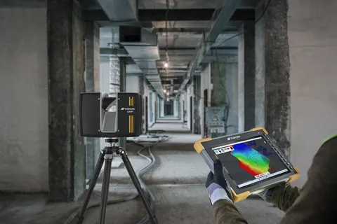
Central to the new offering is the CR-P1 multi-functional 3D laser scanner, the first result of a strategic partnership between Topcon and FARO Technologies—a well-established name in the laser scanning and reality capture industry. This collaboration marks a significant step toward creating more accessible and comprehensive scanning solutions that are designed to serve multiple industry verticals.
The CR-P1 scanner provides rapid, accurate, and high-resolution data collection capabilities. When used alongside the Collage Site software, it enables in-field generation of georeferenced point clouds, allowing teams to immediately assess, annotate, and act on the information being captured.
By reducing the need for repeated site visits and post-processing delays, the combined hardware-software system contributes directly to cost savings and productivity gains.
Topcon’s latest product announcements reflect a broader shift in the construction and surveying industries toward digitally enabled workflows. These new tools are designed not just to improve accuracy, but also to streamline processes and enhance collaboration among various stakeholders.
“Our partnership with FARO and our continued investment in workflow innovations are part of a larger effort to democratize 3D mass data solutions,” said Lodge. “We’re helping expand access to these technologies beyond traditional users to a much wider range of professionals who can now benefit from high-quality 3D data.”
Topcon’s solutions are well-positioned to support smart city planning, real-time monitoring, and integrated BIM (Building Information Modeling) applications, where 3D accuracy and data reliability are critical.
The new solutions will be showcased at Bauma 2025, one of the world’s leading trade fairs for construction and mining machinery. Attendees can visit Topcon’s exhibit in Hall A2, Stand 249, to see live demonstrations and interact with experts from Topcon’s team. The event runs from April 7 to 13 in Munich, Germany.
These demonstrations will provide professionals with a firsthand look at how the software and hardware integrations work together in practical field applications. Users can expect to see detailed workflows, from scanning through to modeling and verification, all executed in real-time.